Drone Scanning
Drone Scanning
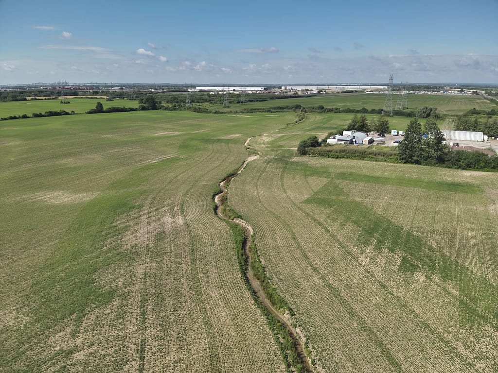
Drone scanning and Aerial Photography & Videography, Photogrammetry, Surveying and Mapping, agricultural Monitoring and Infrastructure and Industrial Inspection
Revolutionizing Mapping & Analysis with Frontier Metrology Inc.
Frontier Metrology Inc. is proud to bring cutting-edge drone scanning services to businesses across the US and Canada, transforming how large and complex areas are mapped and analyzed. Whether you’re in construction, agriculture, or the commercial sector, our high-resolution aerial drone surveys are designed to deliver unmatched precision, efficiency, and value tailored to meet your unique project needs.
Why Choose Frontier Metrology's Drone Scanning?
We understand your challenges when capturing accurate, real-world data for your projects. Our drone scanning services are built on a foundation of advanced technology, industry expertise, and customer-focused solutions to ensure your projects succeed.
Questions?
We've got answers!
Key Features of Our Drone Scanning Services:
High-Resolution 3D Mapping
Capture every detail, no matter the scale or complexity of your project.
Rapid Data Collection
Significant reductions in project timelines for better efficiency.
Cost-Effective Solutions
Advanced scanning technologies at accessible rates, saving your business time and money.
Customizable to Your Needs
Tailored services for construction, agriculture, and commercial projects.
Comprehensive Analysis & Reporting
Actionable insights to drive smarter decisions and mitigate risks.
Scalable Services for any Size Project
Whether scanning large corridors or properties, no project is too big or too small.
How Our Drone Scanning Can Elevate Your Industry
Construction
Save time on-site and improve project accuracy with our cutting-edge drone scanning services. From detailed topographic mapping to in-depth condition assessments, our technology equips you with the data needed for better decision-making. Our drones deliver precise, high-resolution visuals for site planning, infrastructure development, and project monitoring, helping to reduce errors and streamline operations. With faster data collection and analysis, you can stay ahead of deadlines, reduce costs, and ensure optimal safety on-site. Let us help you build with confidence, every step of the way.
Agriculture
Transform your agricultural operations with real-time insights powered by our advanced drone technology. Monitor crop health with high-resolution imagery, assess irrigation systems for efficiency, and analyze topography to optimize planting strategies. Precision farming starts with accurate data, and our drones deliver the detailed information you need to effectively manage water, fertilizer, and other resources. Identifying problem areas quickly can improve productivity, reduce waste, and increase overall yields. Managing a small farm or a large-scale agricultural operation becomes smarter and more sustainable with our drone scanning services.
Commercial
Unlock valuable insights for your commercial projects with our drone scanning technology. Our drones deliver accurate, high-quality 3D geospatial data to simplify complex tasks, from infrastructure inspections and asset management to large property surveys. From identifying potential issues in hard-to-reach areas to evaluating large properties with precision, our services reduce inefficiencies and save time. Plus, with fast and secure data delivery, you can access the information you need without delays. Perfect for property developers, asset managers, and commercial surveyors, our drone scanning services help you make informed decisions and achieve better results.
From Data to Decisions – How it Works
1. Initial Consultation
Share your project goals, and we'll design a custom scanning solution that meets your needs.
2. Aerial Data Capture
Our drones use state-of-the-art technology to perform aerial scans safely and efficiently.
3. 3D Mapping & Analysis
We create high-resolution 3D models and provide detailed reporting for resource management and planning.
4. Actionable Insights
Use our data-driven insights to make better-informed decisions, reduce risks, and improve your bottom line.
Benefits Beyond Numbers
With Frontier Metrology’s drone scanning solutions, you’re not just investing in advanced technology. You’re gaining a partner who is committed to delivering value with every project. From eliminating safety risks to cutting costs and streamlining processes, we work hand-in-hand with you to create opportunities for growth and success.
Get Started Today!
Discover how Frontier Metrology’s drone scanning services can transform your business. We specialize in high-quality aerial drone surveys for organizations across US & Canada. Contact us today for a consultation or to request a quote!
Your Data. Your Success.
Explore the future of site scanning with trusted experts who care about your results. Elevate your projects with precision, safety, and cost-effective solutions from Frontier Metrology Inc.
Let's get started!
Call or email our team for an estimate.